|
I have been a bit intrigue into the investigation of many things, especially as a student of knowledge...higher learning can only consist of that which is scripture based, for as Muslims we know the Quran to be the source of ultimate truth explaining all things. Therefore, by it science & contemptible knowledge is given a light of orientation and subjugation. Unfortunately, we also know that is by the truth that the deceives use as reference to plant falsehood. Generations of predecessors were clearly closer to the truth in comparison to today because of their love of reading.
Even land borders and the actual way the world appears is given to use by the same secularist opinions. Really, think about that for a minute...This may seem a little far fetched in opinion, but let me assure you that it is precisely those ideals or thoughts that tend to come across the mind that are then disregarded as conspiracy. Where, in fact politically these notion help to distort the overall view or understanding that can then later distort the actual size of countries, boundaries, and positions. Furthermore, the ego-centrism of Europeans has known no limits to their corruption and deception in eradicating existing history that pre-dates them...
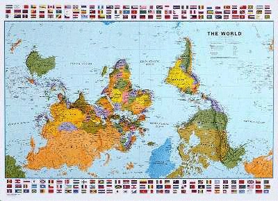
For many people today, that projection of half circled viewpoints depicting Eastern & Western world views− invented by the Flemish cartographer Gerardus Mercator in 1569 − is the world map.The main reason Mercator's projection became so popular was because of its navigational usefulness; in his map, straight lines represent lines of constant compass bearing. However, in manipulating the map to ensure this feature, the sizes of countries become hugely distorted. In particular, the southern hemisphere appears much smaller than it is in reality. There is nothing inevitable or intrinsically correct — not in geographic, cartographic or even philosophical terms — about the north being represented as up, because up on a map is a human construction, not a natural one. Some of the very earliest Egyptian maps show the south as up, presumably equating the Nile’s northward flow with the force of gravity. And there was a long stretch in the medieval era when most European maps were drawn with the east on the top. If there was any doubt about this move’s religious significance, they illuminated it with their maps’ pious illustrations, whether of Adam and Eve or Christ enthroned. In the same period, Arab map makers often drew maps with the south facing up, possibly because this was how the Chinese did it also. Things changed with the age of exploration. Like the Renaissance, this era didn’t start in Northern Europe. It began in the Mediterranean, somewhere between Europe and the Arab world. In the 14th and 15th centuries, increasingly precise navigational maps of the Mediterranean Sea and its many ports called Portolan charts appeared. They were designed for use by mariners navigating the sea’s trade routes with the help of a recently adopted technology, the compass. These maps had no real up or down — pictures and words faced in all sorts of directions, generally pointing inward from the edge of the map. All of such ideals & politics bring question marks to the whole global warming rhetoric etc. What's facinating to me besides the learning, is how everything is that was hidden is re-emerging by the will of Allah in opposition to the massive use of media & secular view points and their claims to authority/legality... 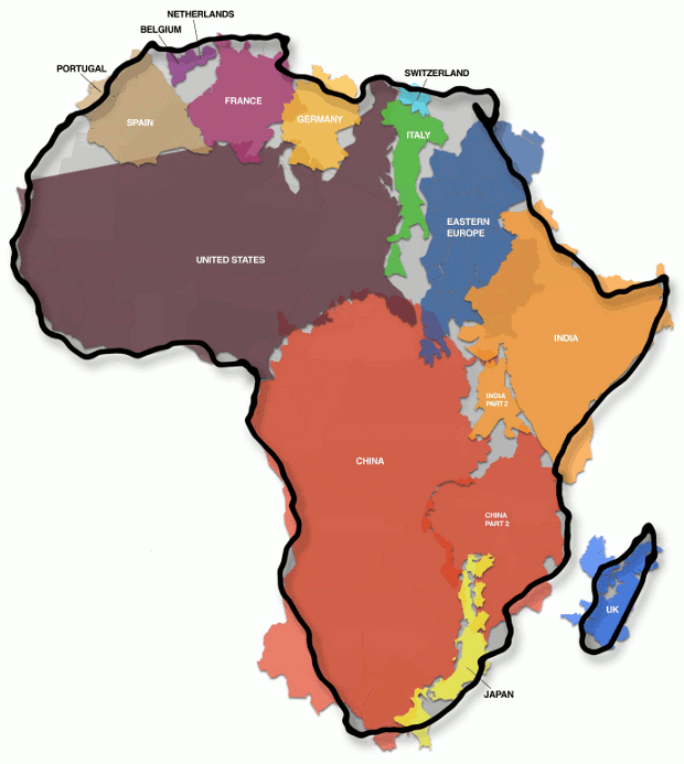
0 Comments
|
AuthorSayyar Isma'il ArchivesCategories |
- Bismi'llah Ar'rahman Ar'rahim
- Welcome....
- About Me
- Contact
- ALCHEMY OF MYSTICISM
- Blog Why Science doesn\\\\\\\\\\\\\\\\\\\\\\\\\\\\\\\\\\\\\\\\\'t Believe in God
- Letters from The Prophet Muhammad s.a.w
- The Glad Tidings of Muhammad s.a.w.
- THE MIRACLE PRESENTED TO MUHAMMAD s.a.w.
- BRIEF STORY OF NEVER ENDING HUMAN WANT
- What Jewish Scholars say about Islam
- OUR ROLE MODELS
- The Rule of Just Leadership (Islam)
- SCIENCE & ISLAM
- Miracle in the Name of \\\\\\\\\\\\\\\\\\\\"Allah\\\\\\\\\\\\\\\\\\\\"
- Ad' Dajjal...the false Messiah
- Ibliss....the Race of Jinn
- Stories of the Prophets...
- Stories of the Companions (sahaba) of Nabi Muhammad s.a.w
- An Explanation of Ramadan
- BYZANTINE EMPIRE
- Blog Femanine Reveloution
- CHAPTER FROM "WHERE DOES THE TRUTH BEGIN"
- Language
- لحقيقة على الباطل Truth over Falsehood Productions
- Blog \\\\\\\\\\\\"WAR\\\\\\\\\\\\"
- Blog Racism the forgotten powder keg
- Reform....Requires ACTION
- How does someone really know themselves?
- Time management...
- Cancer \\\\"The Fastest Growing Disease Today\\\\"
- Blog Ahadith \\\\"The authentic collection of what Prophet Muhammad s.a.w Said\\\\"
- Prison for the Believer & Paradise for a Disbeliever
- The Giants of AD
- The Nation of Thalmud...
- Battles...Badr & The Trench
- Battles of Uhud
- The Movie...The first followers of Muhammad s.a.w.
- DEATH...
- The Plot...
- DNA
- HALLEY'S COMET
- SIGHT
- ORBITS OF PLANETS....
- TELEVISION
- PERIODIC TABLE
- OZONE LAYER
- THE FORMATION OF MILK
- MAJOR & MINOR SIGNS...
- AMERICA...
- Fine Tuning of Creation
- Women's Rights in Islam Explained
- Blog Modernity vs The Stone-Age...
- Blog Separation of Church & State
- Blog Treaty between the United States and the \\\\\\\\\\\\\\\\\\\\\\\\\\\\\\\\\\\\\\\\\\\\\\\\\\\\\\\\\\\\\\\\\\\\\\\\\\\\\\\\\\\\\\\\\\\\"Moors\\\\\\\\\\\\\\\\\\\\\\\\\\\\\\\\\\\\\\\\\\\\\\\\\\\\\\\\\\\\\\\\\\\\\\\\\\\\\\\\\\\\\\\\\\\\"
- Blog Sovereignty...the erosion the of the Constitution
- Blog What was said yesterday?
- Blog Modern Paganism....
- Bible, Jesus, and Christian understanding
- Blog MUSLIMS...OUR UMMAH & OUR LANDS
- Reasons for Revelation...
- Blog Country? or Corporation?...
- Are We There Yet?
- Blog Psychiatrist
- Change the World...Bridge the Gap
- Letters from Prison
- Blog The Great Tribulations of the End Times
- Women's Rights in Islam Explained
- Blog The Khazar Empire
- Blog Our World
- Blog Things to Think about
- Blog motivations
- 3 mins til Midnight
- Blog The Jinn
- Angels
- Allah, Creation, and Answers
- The Arabs
- When the Truth Comes...listen
- \\\\"The Open Door\\\\" Al-Babu Maftahu
- Blog N.O.I
- Vol 1 Weaponized Psychology
- Volume 2 Perception is the Commodity
- Monotheism...Islam is the only true monotheistic religion
- Sulaiman a.s. (Prophet Solomon a.s.)
- Blog How to read a book
- United Nations
- Milestones...
- Heros of Islam
- Fruitition of Efforts
- Update Fruits of my Efforts
- Blog Greater Israel Project
- Vol. 3 Extremeism
- Dreams
- Listen "PRELUDE POETRY TO BLACK THOUGHT COMMITMENT"
- Trapped with Liars
- vol 4 "Black Commitment"
- True Gospels of Barnabus
- Volume 5 Fitrah "the natural disposition of the human-being"
- Funerals are for the Living
- The Weak and Arrogant
- Sins Divide Us Vol. 7
- The Night and the Day
- Endeavours
- Will We Turn On Our Heels
- When Plunder Becomes a Way of Life
- Who’s the Savage
- Human Weaknesses
- To many people, Using to much Stuff
- Hypocrites
- Islam
- Before Columbus
- Jews
- Shakespearean authorized Zionism
- An-Nasara....The Christians
- Healing
- Khawarij
- Brutality towards Muslims
- Materialism
- Normal
- The Narrative
- Wisdom
- Being Muslim
- The Grandeur of Greed
- Lust
- Pride
- Gluttony
- Anger
- Laziness
- ِenvy
- Kings
- The Human and Animal
- Awaken the Dead Heart
- Emotional Responses
- Avatar
- The Matrix
- COVid19
- The Imperial Prison
- Sabotage
- Before we even got a Chance...
- His- Story
- The Prince
- Living
- Electrical Sensitivity
- Census...who are You?
- Nuh (Noah)
- Fall upon your own Sword
- children of Israel
- Put your hands Up
- Jasad
- Everything in Nothing
- Through the Forge
- Snitch Nation
- Obligation of an Artist
- Move to the edge of the Earth
- Ry-Bread
- continued pages قيقة علي البطل
- Lioness
- Seek Knowledge before Vengance
- Trap Door
- Like this Ant…
- Aging
- Family Matters
- Seek to be Wise
- Battle Within
- Falsehood
- Speaking with Two Youths in da Backyard
- Jewels
 RSS Feed
